ISA World Junior Surfing Championships
Updated: Friday evening, October 16th (Local Time)
Brief Overview: Fun size blend of SW/SSW swell and shorter-period NW windswell through the weekend, with better new SW/SSW and WNW swells creeping up Sunday afternoon. Light/variable winds provide the cleanest conditions each morning, giving way to Westerly flow in the afternoons.
SATURDAY 17th: 3-4’+ wave faces, with occasional larger sets on the best tides. Cleanest in the morning with light/variable onshore wind, trending light to moderate onshore in the afternoon.
Swell: Mix of reinforcing SW Southern Hemisphere swell and small NW windswell. Less broken up swell mix, but still some occasional peaks/corners.
Wind/Weather: Mostly cloudy with a marine layer early, giving way to partly sunny skies in the afternoon. Light/variable onshore wind in the early to mid morning, trending light onshore by the later morning from the W. WNW wind builds in the afternoon 6-10kts.
SUNDAY 18th: 3-4’+ wave faces, with occasional larger sets on the best tides. Clean in the morning with light wind, trending light+ onshore in the afternoon.
Swell: Mix of SW Southern Hemisphere swell and minor NW windswell joined by building forerunners of new SW/SSW and WNW swells through the afternoon. Broken up swell mix with occasional peaks/corners. Slight uptick in size through the afternoon.
Wind/Weather: Mostly cloudy with a marine layer early, giving way to partly sunny skies in the afternoon. Light/variable ESE/SE wind early trends Southerly and picks up through the morning. Light to moderate onshore wind from the WSW in the afternoon 4-9kts.
Swell/Surf Outlook
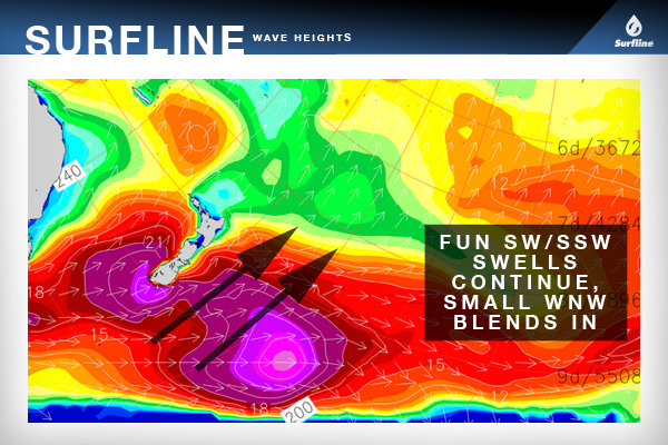
Modest pulse of SW/SSW swell (220-200) is on offer over the weekend, with a slightly better SW/SSW swell (220-200) showing through the afternoon Sunday with long period forerunners. Shorter-period NW windswell joins in the next couple days, with some fresh WNW swell (280-300+) creeping in late Sunday from a frontal low active in the Gulf of Alaska now.
The combo of SW/SSW swells and NW windswell will continue to offer fun surf through the weekend in the waist-shoulder high zone, with a few shoulder high+ peaks possible during the best tides. Shape is semi broken-up on Saturday, and should get a little more crossed-up on Sunday (though neither day will offer shape rivaling that from early in the week).
The combo of SW/SSW and WNW swells will continue to offer fun surf through the end of the week (waist-shoulder occ. head high). For the weekend we expect to see a new, overlapping run of SW swells and NW windswell set up more waist-shoulder high waves with occasional larger peaks around the more favorable tides.
Wind/Weather: Look for light/variable onshore Westerly flow to prevail early Saturday under mostly cloudy skies. Winds trend up through the morning, giving way to a light to moderate W/WNW sea-breeze in the afternoon as skies partially clear. Sunday remains a little dicey as a low moves through north of the region. It appears that will deliver light/variable ESE/SE flow early, with winds trending Southerly through the morning. Light to moderate WSW flow develops in the afternoon, but looks a little lighter than the onshore flow due Saturday afternoon.
Next Update: This is the final update.
-Schaler
Schaler Perry

